YaDing's Lost Sichuan
by Yan YaDing © 2013
 For several years I've set myself the delightful task of photographing Sichuan landscapes and villages. In so doing I have anticipated the changes that were to come. Through conversations with local inhabitants I gathered information about the significance of buildings and streets.. Part of my photos are from areas that are now flooded. Soon these places will only be marked on old maps, easily deleted and forgotten.
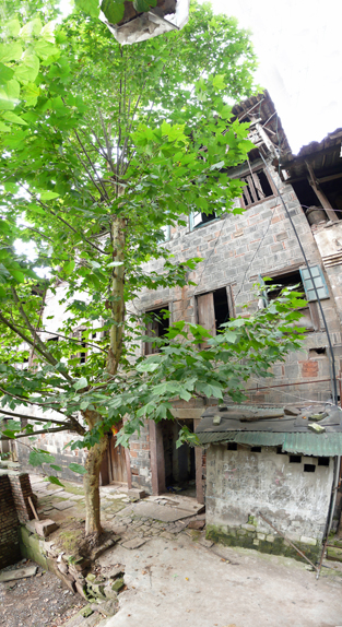
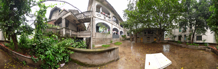
The stories behind my photos are valuable local history. Once upon a time the forces that shaped today's China swept through such places and changed the fortunes of individuals profoundly. For instance, the house behind the lovely buttonwood tree belonged to he local Kuomintang 中华民国 leader.The owner of the second house was killed in battle. He was famous for a very short time during the Kuomintang reign. He was killed by the communist forces not far from his house.
.
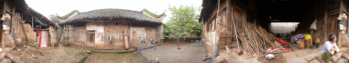
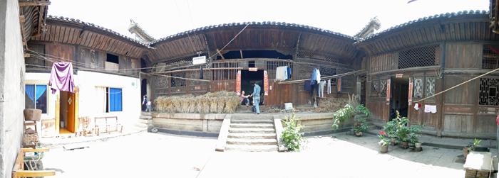
The third house was the administrative headquarters of Pinyi Tusi, read more on http://en.wikipedia.org/wiki/Tusi.
Click images below for panoramic view - Java required.
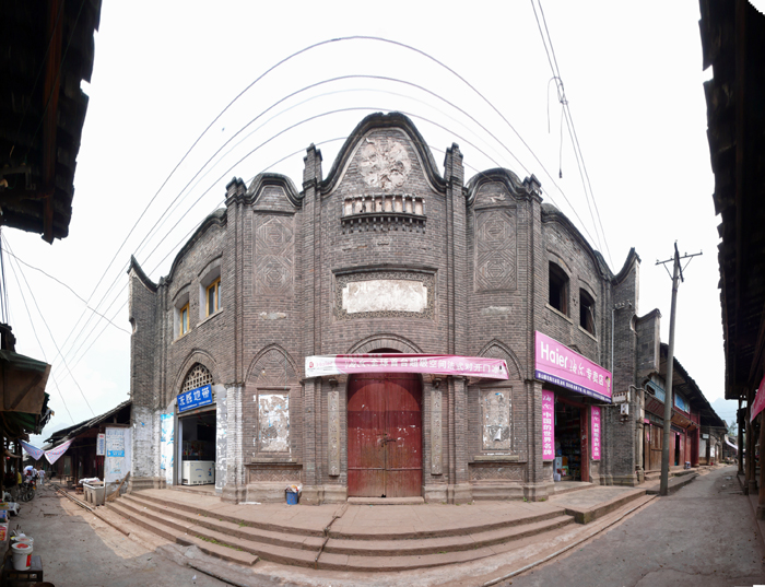
Architectural styles changes. Take a look at these two buidings. The first building was built in the 20th century, the second much earlier. You can easily see the impact of foreign cultures at the time China was transformed from monarchy to republic.
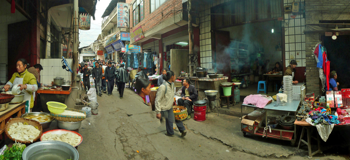
I learned, when talking with local people, that a street barely a hundred meters long, had been an important commercial centre. For this surprising fact to make sense, one had to understand the geography and the administrative structure of the entire area. Farmers from near and far came here to sell their produce and buy equipment. This tiny street was as vital to them as Hong Kong and Shanghai are to business men today. They traded their crops to buy textiles, tools and even books. Thus the elements of a modern economy reached its tentacles far into the high mountains of Sichuan and along the Yangzhe valley.
The theme is the same throughout my series of photographs - change.
Lost Sichuan Cavalcade
马湖江,旧时指金沙江在宜宾至金阳段,因马湖府而得明,马湖江沿岸,分布着沉淀了厚重历史和人文的古镇和遗迹,这些历史的印迹最终敌不过世事的变迁,最终淹没在向家坝水位线以下。幸运的是我能在他们被淹没前,游历了其中的许多地方,与当地人攀谈,了解并尽可能深入理解其历史变迁与当地居民的关系,从这个角度讲,这是一次有意义的游历
谈及历史的变迁很难完全不谈及政治,第一张图片是位于老屏山的一所老宅,据当地老人介绍,这所房屋曾经是屏山县国民党党部书记(凌JIE)的,其特别的烟囱位于二楼与三楼之间,设计非常精巧。而第二所位于新市镇房屋的主人命运就比较悲惨了,照片拍摄时,这所房屋为屏山县新市镇区公所(当地政府),原为何霁光的家宅,何霁光其曾以国民党“省参议员”身份竞选屏山“国大代表”,在当地也算得上头面人物,1950年6月27日,何霁光带领的国民党残部在黄琅相继歼灭。
第三张照片是屏山县新安镇平夷司衙门中土司审案的地方,据照片中的当地人介绍,审案的时候,平夷司长官会坐在途中箩筐和竹竿之间的位置上,而犯人会被押在两座建筑中间空地上。由于当时平夷司掌管的地盘很广,从平夷司衙门向东一直到向家坝坝址的约40公里金沙江流域(辖区精确信息较难精确了解)都属于平夷司管理,所以还会出现从下游很费力气的把犯人用纤夫拉的木船押解到上游提审的情况,鉴于金沙江行船原本就很艰辛,所以我相信在这个平夷司辖区,提审犯人以及其他公务活动都是很艰难的。
根据一位绥江老人的记忆,1949年中华人民共和国成立时,平夷司衙门建筑群的规模都还很大,整个衙门使用抹有白粉的砖墙合围而成,占地很宽,整个衙门由多重建筑构成。平夷司的历史地位曾经很高,其统管马边、雷波,所以曾经一度成为了当时马湖府的政治、经济、文化中心。当马湖府搬迁至屏山(安上)后,其地位逐渐衰落,直至2009年照片拍摄时,新安镇的行政级别仅为屏山县的一个乡。
两幅楼东乡的古建筑反映了建筑风格在几百年间的变迁,砖砌的大院门据当地人介绍是在1900年后,由当地凌姓的大家族从成都聘请工匠修建的,但是请大家注意,楼东乡是1999年才通的公路,是屏山县最后一个通公路的乡,此前都只能靠船和人力背驼的,即使是船运,在中华人民共和国成立很长一段时间后,都还是靠纤夫拉木船。从建筑的风格我们能够看出西方教堂建筑的元素(拱门、立柱、方窗)与中国传统建筑元素(飞檐、黑色和白色纹饰、石雕对联、房顶的梯形曲线)的相互融合。而在20世纪初期,也是中国从帝制转向共和制的转型期,由此可见一个社会的变革总是全面、深刻而且长期的,即使是在这样一个远离各种文明的楼东乡。
下面的照片是永善县桧溪镇的集市,桧溪镇是一个位于峡谷地区的小集镇,但是由于当地地理条件极其险要,经济落后,生活在高山里的村民们到这里来进行农产品交易,购买生活必需品,虽然这里的经济总量不能与香港、上海这样的商业中心相比,不过,就当地而言,却是我观察各种基础经济学现象的好模型。
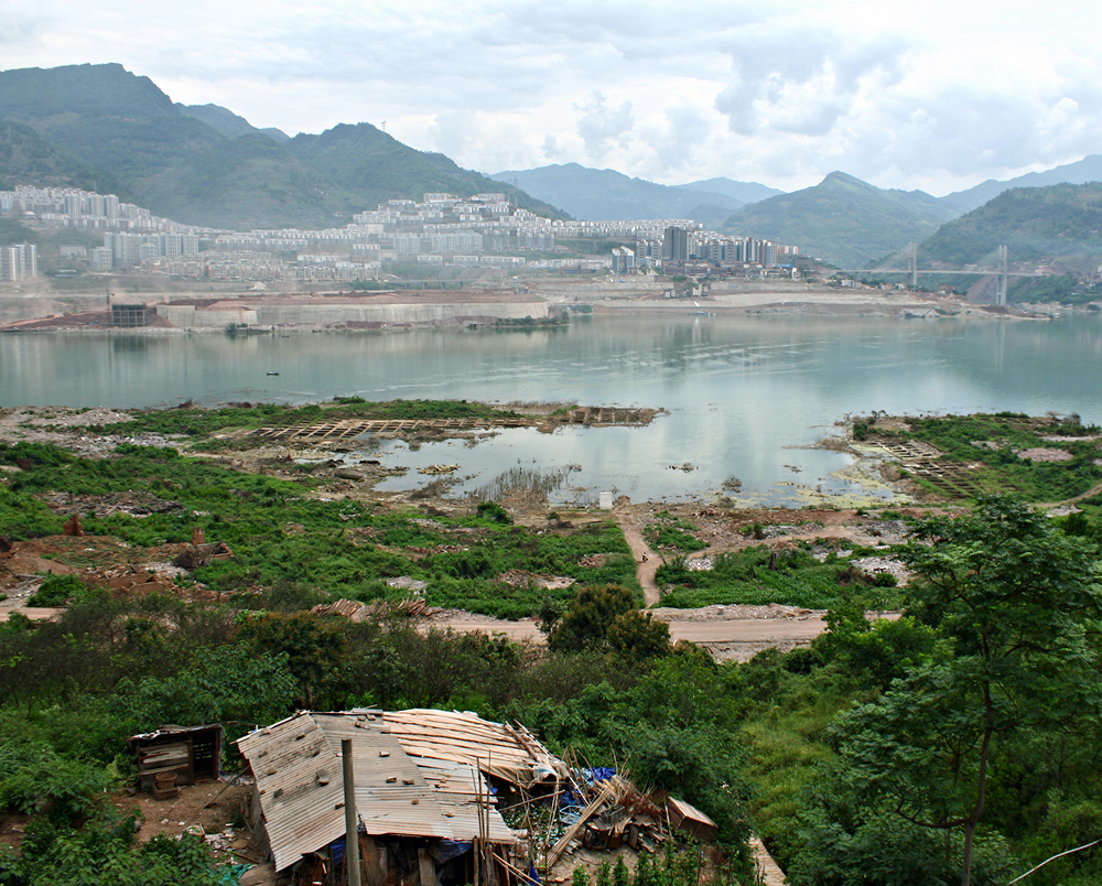
最后的一张照片是当前向家坝库区的风光,从前的故事已经离开了他们诞生的地方。